
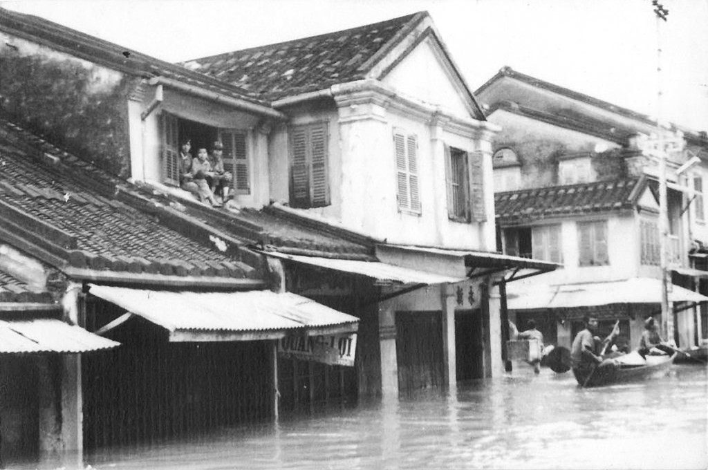
The flood has come
The Italian Jesuit Cristoforo Borri lived in Đàng Trong, the southern realm Europeans charted as CochinchinaHISTORICAL EXONYMCochinchinaAn old place name that meant different parts of Việt Nam in different periods. In the 16th and 17th centuries Europeans used it for the whole of Đại Việt, or for Đàng Trong alone — the southern realm of the Nguyễn lords. Under French rule the sense narrowed again, to Nam Kỳ, the south of the country. The land it named was Vietnamese throughout; only the foreigners' word for it kept moving., from 1618 to 1622, and spent time at Hội An. His account, printed at Rome in 1631, says that in the rainy season the floodwater covered the whole country and ran to the sea "as though land and sea were one". A flood came roughly every fortnight and lasted three days. It arrived without warning: nobody thought of it in the evening, and by morning the water had closed in on all sides and shut people in their houses.
What struck Borri was that people here wanted the flood. When they saw the season coming they called on one another, embraced, and shouted "the flood has come, the flood has come". Nobody stood outside that festivity, the ruler included. Silt came with it and made the fields rich, and for those three days a boat could reach any lane. He recorded one more thing: houses stood on tall columns so the water could pass under freely, and the owners had taken "the exact measure, from long experience, of how high and low the water runs".
For the three days of the flood the country followed a custom Borri called a very gracious law: cattle, goats and pigs drowned in the water were lost to their owners and belonged by right to whoever took them first. As soon as the water rose, men pushed off in boats to collect them, and afterwards they held a feast. Boys rowed out over the fields and shook the trees to bring down rats, whose flight from the water left the branches loaded, he wrote, in place of leaves and fruit.
Because the whole country could be crossed by boat, people set the largest fairs of the year to fall exactly then, and the crowds were greater than at any other season. Timber came down from the hills on the same water, the boats moving along the streets and into the houses themselves. The silt left the fields good for three harvests a year. Borri wrote that nobody there had to hire himself out in order to eat.
Four centuries ago, people were already sizing their houses against a memory of water.
Twenty-four years of flood
On the 24th day of the tenth month of Cảnh Hưng 19, which is 1758, the harbour superintendent issued an order to Minh Hương village and its assembly hall: clear the drains through to the river against flood and fire. The order named the stretch of road in front of Cây Me pagoda. It is an administrative document rather than a description, which makes it firmer evidence than any recollection that flood defence at Hội An was a matter of state.
A study drawn from the Nguyễn chronicles lists storms or floods reaching Quảng Nam in twenty-four separate years between 1825 and 1882. The imperial gazetteer compressed the region's whole climate into a line: autumn brings a cool wind and a habit of flooding, with the eighth, ninth and tenth months the wet ones. The old law reckoned with the weather as well. Where storm, flood, drought or insects destroyed part of a harvest, the district authorities could grant a reduction in tax, and a French-language bulletin published at Huế in 1919 preserved the rule by which the reduction was worked out.
The chronicles kept the cost as well. In the ninth month of 1879, 1,503 houses collapsed across four districts and 122 people died. In 1878 the water stood more than eleven thước deep in the first surge, close to three metres, and more than nine in the second. The court sent the imperial commissioner Hoàng Diệu to distribute relief and ship in rice.
After the flood of 1878 the imperial chronicle records that a merchant from Qing China at Hội An set up a place to take in children who were being sold, and that the matter was reported to the throne. The emperor ordered relief distributed more widely and ruled that no pledge be required before rice was sold, since keeping people alive counted for more. On the children he forbade Qing traders to carry them out of the country. Whoever had bought one in order to help was to keep the child in the town and later hand it back or allow it to be redeemed, which he called knowing what is right. Where the district could not provide, the children were to be sent as circumstances allowed to the capital, for officials or wealthy households to take in and raise. For any already carried away, public funds were to redeem them at Hong Kong on the next state vessel and return them to their parents.
A stone bank and three junks
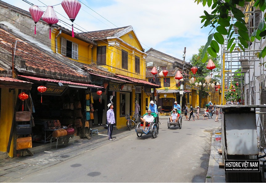
On 3 February 1917 the Résident supérieur, France's senior official in AnnamA NAME IMPOSED FROM THE NORTHAn Nam“An Nam” was the name the Tang court imposed on Việt Nam in order to administer it during the northern domination. Westerners, and later the French, took it up — for the whole country, or for Trung Kỳ alone, the central region where Hội An lies. That is why European maritime records of the 16th–18th centuries usually file this port under the “Royaume d'Annam”, the Kingdom of An Nam., approved construction of the FaifoTRADERS' NAME FOR HỘI ANFaifoWhat foreign merchants wrote in their logs for Hội An, commonly explained as coming from Hoài Phố (also recorded as Hải Phố). It was a name for a port of call, not for a foreign possession: the town stood under the Nguyễn lords, and the merchants lived there by their leave.“Hội An” — Wikipedia tiếng Việt embankment at a cost of 1,500 piastres, charged to the local budget. The stated reason was drainage and erosion in the wet season. The old town runs along the river and every street and alley opens straight onto the bank, so when the river rises it comes up those same streets into the town.
Quảng Nam was badly flooded that same year. The Liên Thành Company sent three ghe bầu junks of rice up from Phan Thiết. The provincial mandarins reported it to Huế, and the emperor Khải Định granted the company a lacquered board bearing four characters, its dutiful charity is worthy of praise.THE FOUR CHARACTERSHiếu nghĩa khả giaThe Vietnamese reading of the four characters as the record gives them. No source in this archive prints the characters themselves.Nguyễn Văn Thịnh (2025) — Trung tâm QLBT Di sản Văn hóa Hội An
Relief reached Hội An by water almost half a century before it arrived by air.
When the rainbow stands in the west
Before there were forecasts, Hội An read the sky. Fishermen watched the colour of the western cloud at sunset: yellow meant sun, white meant wind, red meant heavy rain and the risk of flood. In the tenth month they watched the rainbow. Standing in the east it meant calm, standing in the west it meant a big flood coming. A shorter line circulated among the boat people: a long rainbow brings flood, a stubby one brings rain.AS THE BOAT PEOPLE SAY ITmống dài thì lụt, mống cụt thì mưaKhiếu Thị Hoài (2024) — Trung tâm QLBT Di sản Văn hóa Hội An
Those signs were not held in local memory alone. The same French-language bulletin printed a whole table of them as farmers passed them down. Ants building little dikes across a path meant a great flood was coming, ants stopping their nest holes with earth meant torrential rain, and a black halo round the sun meant flood. The rainbow line the boat people used was in that table too, in print by 1919.
On land they watched the water. By the ninth and tenth lunar months, if it rained for days while the onshore wind blew back against the current, the muddy water from upstream could not reach the sea. People called that condition hàn khẩu, a closed mouth, and it meant the flood was near. Whoever could read the signs told the neighbourhood, and word went from one house to the next.
One line is known across the whole province and still said today. It names nobody, and it goes: he may let you off, she will not, and the flood of the twenty-third of the tenth month comes anyway.AS THE PROVINCE SAYS ITÔng tha mà bà chẳng tha
Làm cho cái lụt hăm ba tháng mườiThe line names neither of the two, and everyone in Quảng Nam knows it.Tri thức dân gian về dự báo bão lụt — Trung tâm QLBT Di sản Văn hóa Hội An
Two beams and a plank
A timber house in Hội An has a member called the trính, a horizontal beam tying the main columns of a single frame. Its job is to brace the structure. But in the low-lying wards a single-storey house would have planks or a woven bamboo panel laid across two trính to make a rough loft for seed and stored goods. When the water rose, that storage loft was where the family climbed.
Merchant houses were different. They had wide lofts, and the owner would set the servants to carrying the stock upstairs and stacking it. Houses without a loft raised their belongings onto the heavy wooden daybed, hung the bamboo bed from the beams, sent what they could to higher ground, and moved the old and the young out. Across the river at Cẩm Kim, some families built an earth mound two or three metres high in the garden with a shelter on top for goods and livestock.
The heritage centre's study of what the town remembers lists what a household laid in: rice, salt, fish sauce and greens. Some families cooked a day or two of meals in advance. They put by lamp oil, drinking water, a small clay stove and dry firewood. If the flood was high enough to drown the kitchen, they spread a layer of ash in an aluminium basin and set the trivet on that to cook. If food ran out or someone needed help, they beat on a tin drum, swung a torch through the dark and shouted for the neighbours.
A drought first, then late rain
Năm Thìn, the year of the dragon, brought Quảng Nam a severe drought. The Thu Bồn river ran lower than anyone could remember. The rains came, but later than usual.
Two men of the town who lived through it, Thái Tế Thông and Nguyễn Bội Ngọc, both remembered a very large storm before the flood. People in the old town did not usually fear storms, because the houses are low and lean against one another and hold. This one tore the roofs off many of them. Rain followed, there were small floods, and the water was already backed up with nowhere to go.
The meteorological record has three typhoons making landfall on Vietnam within twelve days: Iris on 4 November, Joan on the 8th, Kate on the 16th. Joan did the most damage. By the tenth lunar month the rain was torrential, the onshore wind was strong, and the water from upstream came down onto ground that was already full.
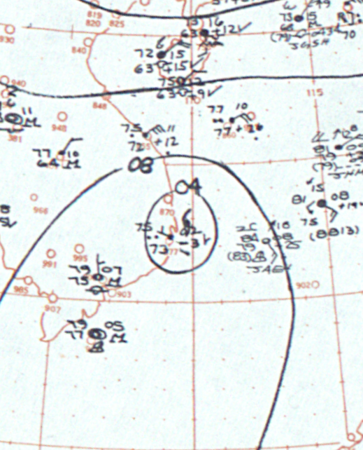 Chart · Wikimedia Commons · public domain
Up to the eaves
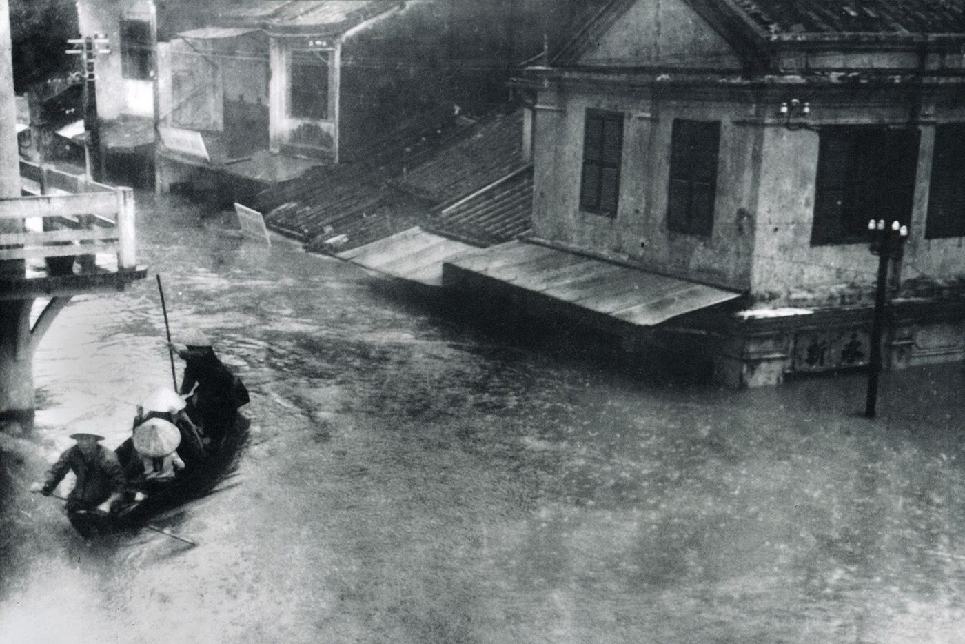
On 9 November 1964, the sixth day of the tenth lunar month, the flood came down hard. The Thu Bồn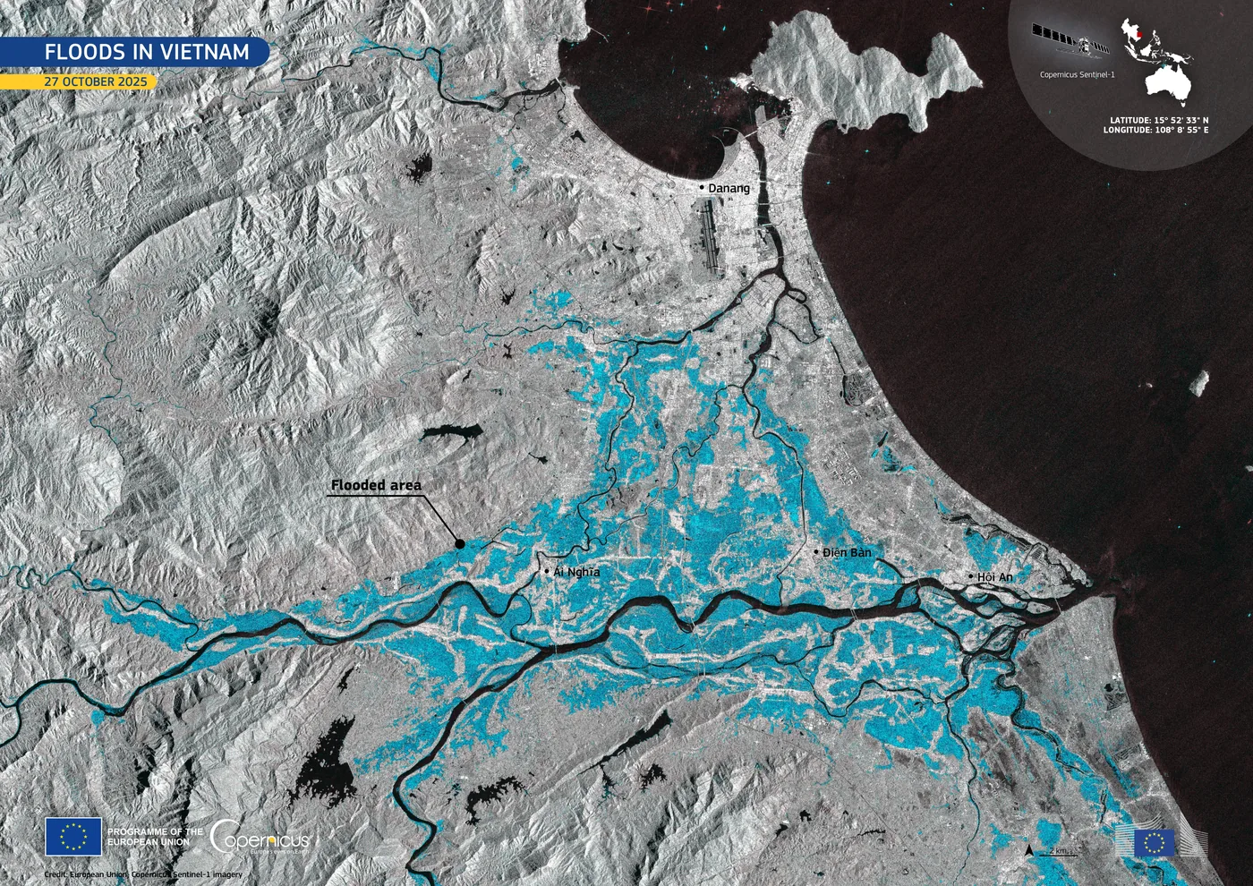 PLACE · RIVERThe Thu Bồn RiverSince the plain existed · to nowAbout 20 km³ of water reaches the sea down the Thu Bồn each year, more than any other river in central Vietnam, and 80 to 90 per cent of it arrives between September and December. The old town of Hội An stands on a sand ridge that the same river built. and the Vu Gia emptied together. The gauge at Hội An recorded a crest of 3.40 metres, and the gauge at Câu Lâu on the same river 5.48 metres.
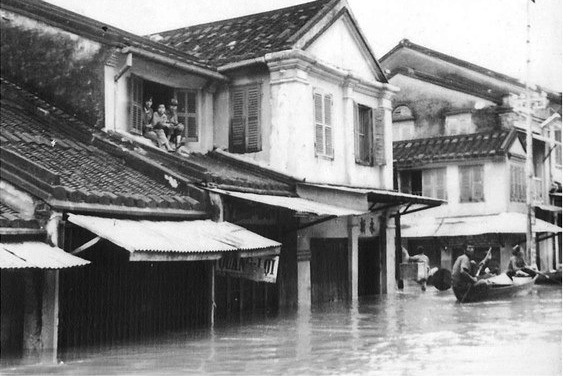
In town the water came up the streets that open onto the river, and the streets became the river. At An Hội, Cẩm Nam and Cẩm Kim it stood about a metre and a half. The Nguyễn Tường clan house in the xóm Dinh quarter sits on the highest ground in its neighbourhood and still took water halfway up the walls. At Cẩm Kim and the pottery village of Nam Diêu many houses went under to the roofline. Almost the whole of Nam Diêu evacuated, and those who stayed climbed onto the brick kilns on high ground or onto the larger boats.
People in the old town who are now in their eighties remember sitting on the upper floor of a house on Nguyễn Thái Học street, watching buffalo, pigs, chickens and whole thatched roofs go past on the current.
Only the roof of the bridge
Thái Tế Thông remembered that the water rose until, looking down the street toward the Bridge Pagoda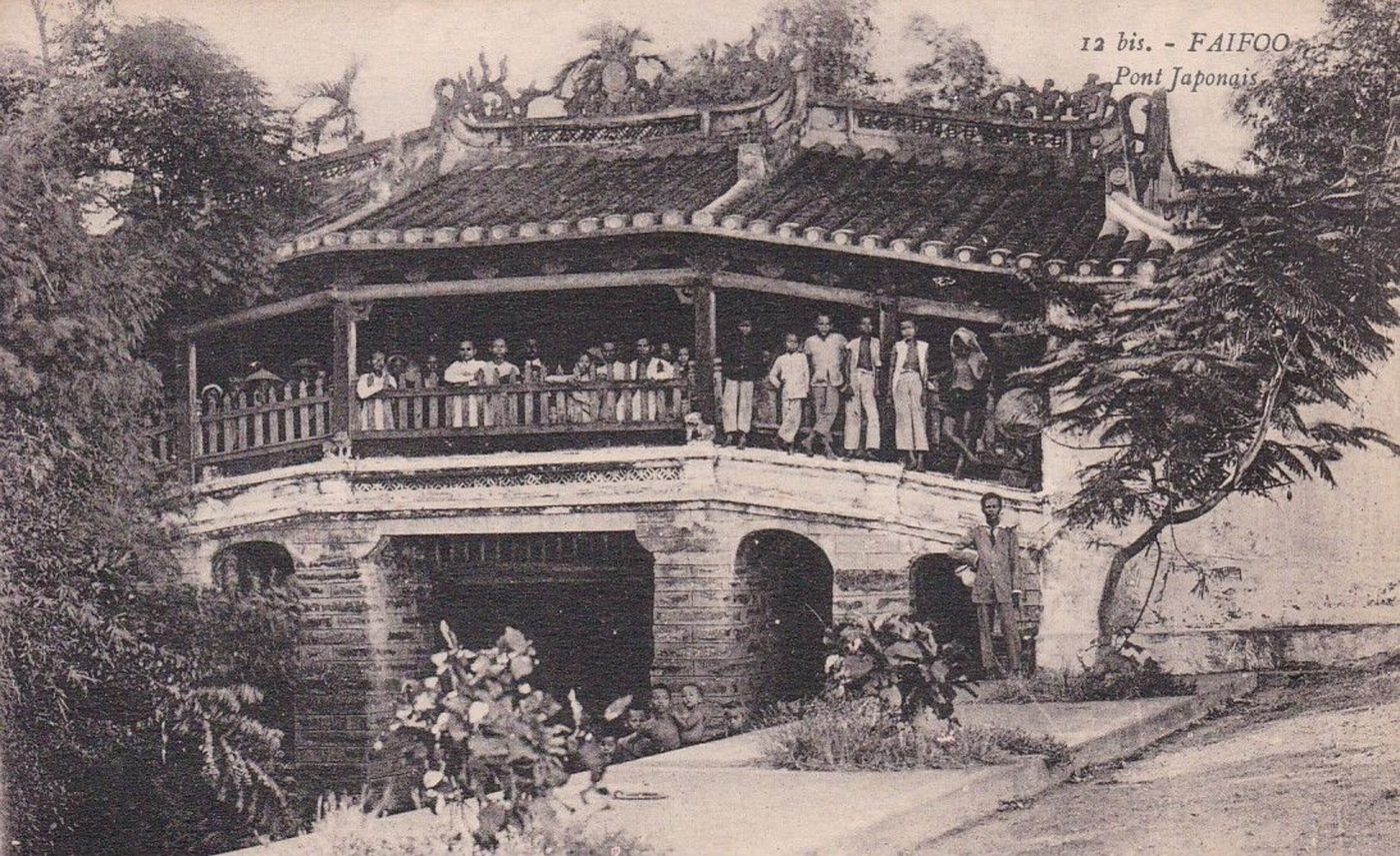 PLACE · ANCIENT TOWNThe Japanese Covered BridgeJapanese merchants paid for it, Vietnamese carpenters built it, a Chinese village kept it, and a Nguyễn lord gave it a name. After eight dismantlings, the part of the four-hundred-year-old bridge that is close to intact is the foundation., all you could see was its roof. The Japanese built that bridge to cross the creek, and Bắc Đế Trấn Vũ
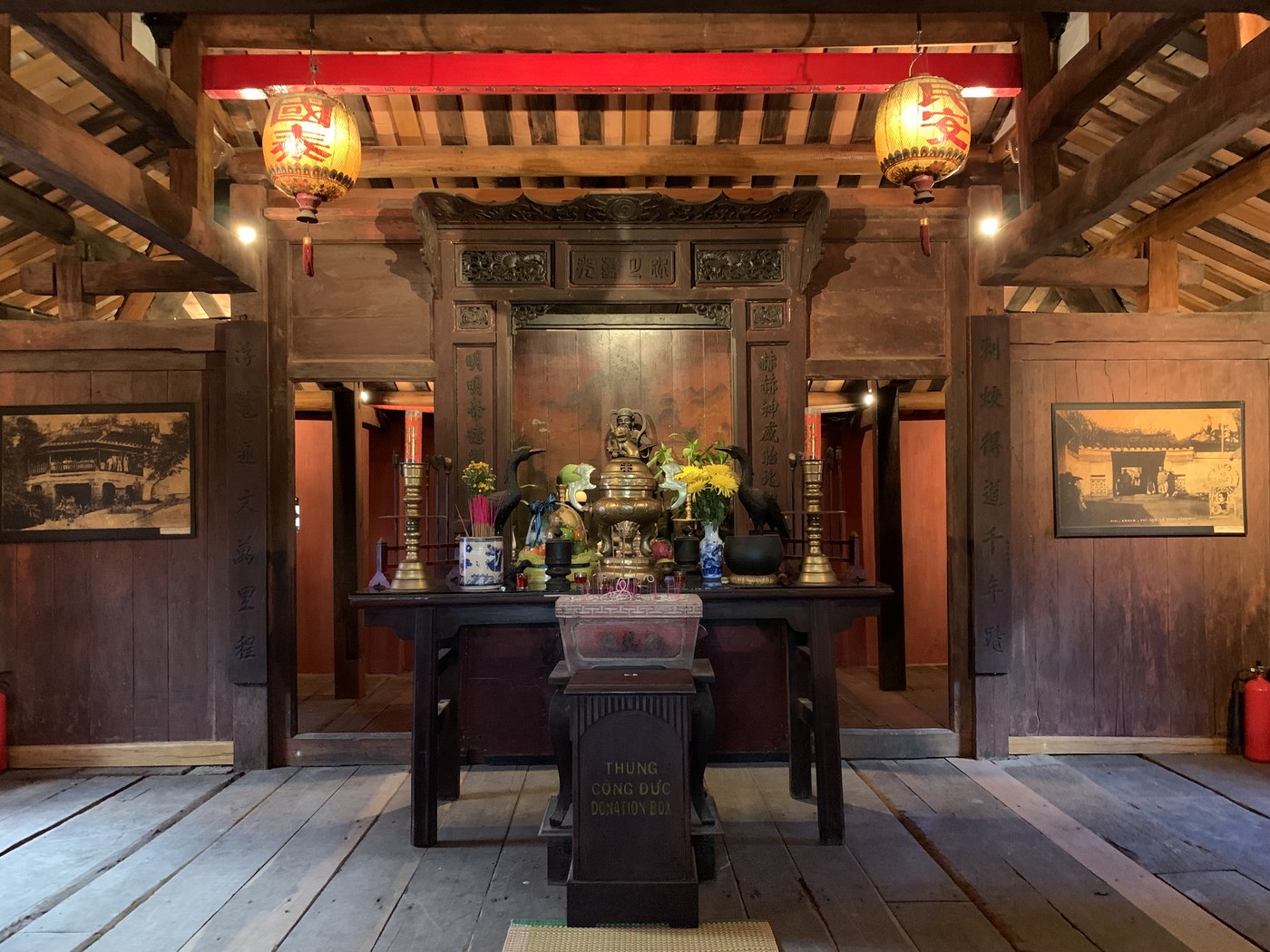 PERSON · DEITYBắc Đế Trấn VũThe Daoist god of the north, charged with the water tribes, who spent forty-two years on Mount Wudang and was then carried to Hội An by Chinese residents, installed in 1653 in a small shrine on a bridge, to do the work that a giant catfish out of Japanese myth had been doing badly. sits in its middle bay to hold down the water monster. That day almost all of it was under water.
No photograph of the bridge during the 1964 flood has been found.
The village of Đông An
Đông An lies upstream on the Thu Bồn, then part of Sơn Ninh commune in Đức Dục district. That evening many villagers went up to Hồ Thị Thanh's house because it stood on the highest ground. At about seven in the evening the water took everything.
According to the register the village elders keep, more than fourteen hundred people died there and a few dozen lived. The provincial paper gives a different count: 1,481 dead and 19 survivors. Hồ Thị Thanh lost her parents, her sister, her elder sister, her husband and her sister's five children, and no body was recovered. A man rowing past pulled her into his boat, and his family took her in for ten days.
Her sister-in-law Lương Thị Lạc was pregnant when the water carried her away, and lived. A month later she gave birth to a daughter and named her Phước, meaning blessing. The village still holds one shared memorial and calls it the flood anniversary. The hamlet head Huỳnh Bá Hạnh says they settled on the fifth day of the tenth lunar month, while the same article describes the incense being lit on the sixth.
Six thousand, or two and a half
The sources do not agree on how many died. This entry shows the disagreement instead of choosing.
Báo Đà Nẵng, the paper of neighbouring Đà Nẵng, puts the total for Quảng Nam at about 6,000 dead and missing. Of those, the three hamlets of An Toàn, Bình Kiều and Thạch Bích in Quế Sơn district account for 5,000, and Đại Lộc for 253 with more than 1,200 houses swept away. Reuters at the time counted at least 2,500 dead in Quảng Nam province. Bert Fraleigh, associate deputy director of the U.S. Operations Mission to Vietnam, counted at least 2,600 in Quảng Tín province. The Los Angeles Times of 13 November 1964 ran the headline that the toll had reached 5,000.
One fact belongs beside those numbers. Decree 162-NV of 31 July 1962 divided Quảng Nam into two provinces, Quảng Nam and Quảng Tín, with the Rù Rì river as the boundary. In 1964 they were two provinces. Today they are one.
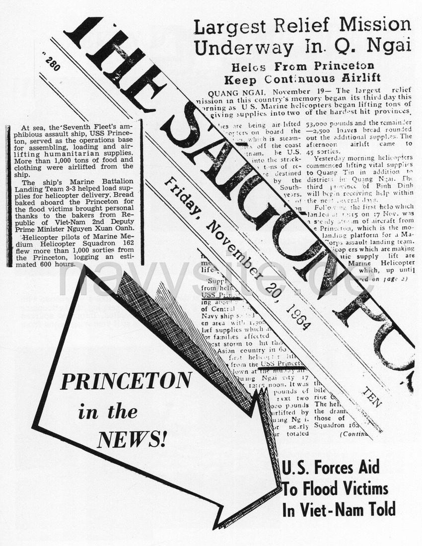
Bread from a flight deck
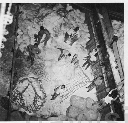
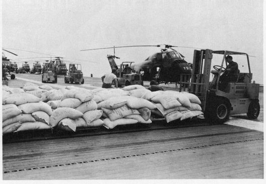
On 17 November 1964 the American helicopter carrier USS Princeton arrived off central Vietnam. Her flight deck became a warehouse, with forklifts running between stacks of sacks and helicopters ranged behind them. Below, sailors stood on a hill of sacks in the hold with the cargo net spread out beside them. Two of the ship's bakers pushed trays of dough into the ovens to make bread for people ashore.
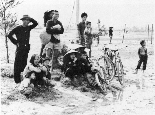
The first helicopter landed on the 17th. The next day the lift extended to Quảng Tín, with the province of Bình Định still some days from receiving anything. On the landing zone at Tam Kỳ, villagers waited for the load: adults standing, children sitting on the sand, bicycles propped at an angle. The Saigon Post of 20 November reported the largest relief mission in the country's memory under way in Quảng Ngãi. By the time the ship left central Vietnamese waters on the 23rd, the helicopter squadron HMM-162 had flown 1,020 sorties and more than six hundred hours.
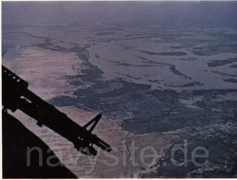
One photograph taken from a helicopter gun port shows the whole delta under water, the river channels bright seams through it.
 Photograph · USS Princeton cruise book 1964–65, p. 70 · U.S. Navy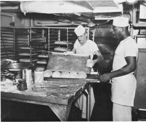
 Photograph · USS Princeton cruise book 1964–65, p. 71 · U.S. Navy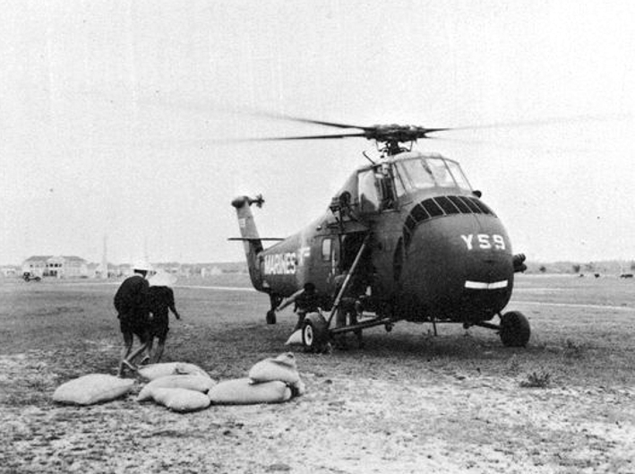
Who took those photographs
The pictures of the flooded old town circulate all over the Vietnamese internet, almost never with a photographer's name. Followed back far enough, they lead to one: the Lệ Ảnh studio, opened in 1930 by Trương Trừng and passed to his sons Trương Thiệp, Trương Nguyên, Trương Thọ, Trương Chữ and Trương Phúc Loan.
Photography in Hội An was a closed trade. The first studio was Thiên Chơn Cát, opened in 1912 by La Doãn Ninh and known locally by its owner's nickname. Thái Thiệt Cổ opened the Tiêu Nhiên studio in 1920, and the Huỳnh Sau studio followed in 1928. Cameras, film, paper and chemicals all had to come from France or Hong Kong. An assistant from outside the family washed trays and dried prints and was not allowed into the darkroom. The work passed from father to son.
Thái Tế Thông, whose account of the bridge under water runs through this entry, ran the Vĩnh Tân studio and was Thái Thiệt Cổ's son. The man who remembers the flood was himself of the photograph trade.
Paint marks on a column
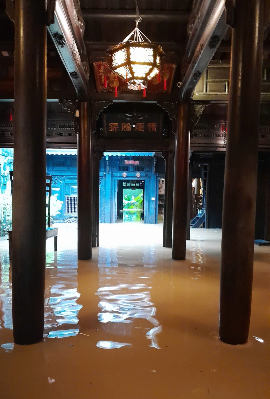
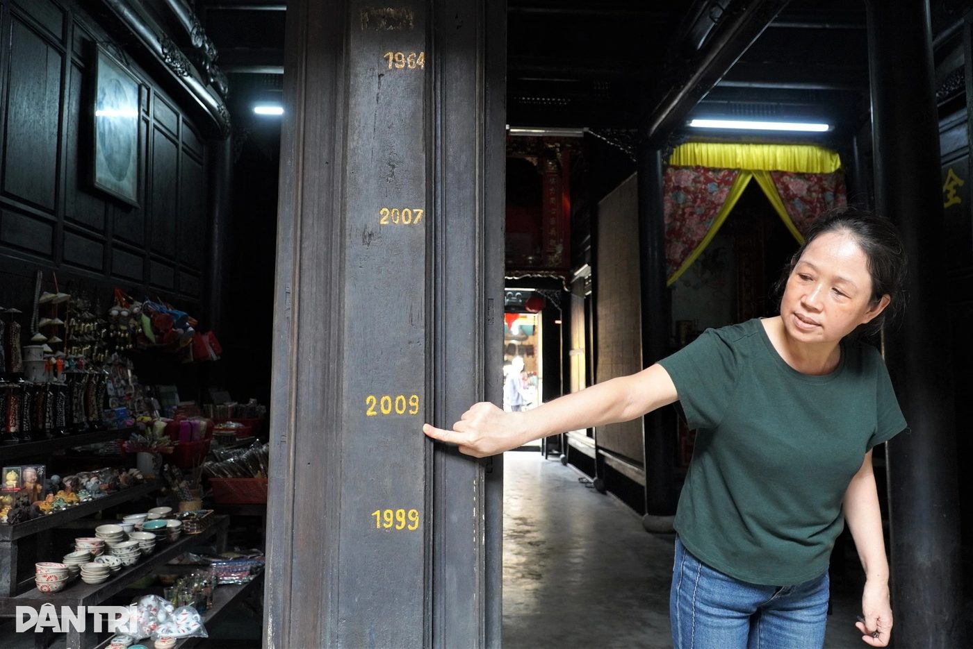
The Quân Thắng house was built by a Chinese merchant of that name. Inside it, on a timber column more than three hundred years old, several yellow lines run across the grain, painted there by earlier generations of the household. The top one reads 1964. Below it come 2007, 2009 and 1999. Diệp Ái Phương, a descendant of that merchant, can reach the 2009 mark with her hand. For 1964 she has to look up.
The Tấn Ký house keeps its own 1964 mark cut into a column, and earlier generations there rigged a pulley to haul belongings up to the loft. The painted lines are not souvenirs. They are the measure Borri described four hundred years earlier, drawn now straight onto the post where the next generation can see it.
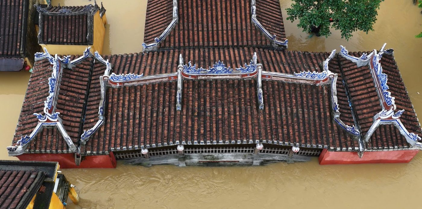
On the morning of 30 October 2025 the regional hydrometeorological station recorded the Thu Bồn at Câu Lâu and Hội An standing higher than the 1964 record. The forecast for Hội An was 3.45 to 3.50 metres, five to ten centimetres above the old mark. That day the water reached the roof of the Bridge Pagoda again, and people brought out the year of the dragon to measure it by.

- Cristoforo Borri, "Xứ Đàng Trong năm 1621" (bản dịch 1998) — dẫn theo Nguyễn Văn Thịnh, Trung tâm QLBT Di sản Văn hóa Hội An
- Nguyễn Văn Thịnh, "Một vài thông tin về lụt và ứng phó với lụt ở Hội An trong lịch sử" — Trung tâm QLBT Di sản Văn hóa Hội An, 04/04/2025 (dẫn Đại Nam thực lục, Đại Nam nhất thống chí, tư liệu xã Minh Hương 1758, hồ sơ bờ kè Faifo 1917)
- Quốc sử quán triều Nguyễn, "Đại Nam thực lục" tập 8 (bản dịch Nxb Giáo dục 2007), tr. 316 — chép trận bão lụt Quảng Nam năm 1878, việc phát chẩn của Khâm sai Hoàng Diệu và lệnh vua về những đứa trẻ bị đem bán. Dẫn theo Nguyễn Văn Thịnh, Trung tâm QLBT Di sản Văn hóa Hội An
- Khiếu Thị Hoài, "Bão lụt và kinh nghiệm ứng phó với bão lụt của cư dân Hội An trước năm 1975 qua tư liệu ký ức cộng đồng" — Trung tâm QLBT Di sản Văn hóa Hội An, 28/10/2024
- Khánh Vân, "Tri thức dân gian về dự báo bão lụt qua tục ngữ, thành ngữ của ngư dân Hội An" — Trung tâm QLBT Di sản Văn hóa Hội An, 16/05/2022
- Ngọc Hương, "Kinh nghiệm trong ứng phó với bão, lụt ở Cẩm Kim - Hội An" — Trung tâm QLBT Di sản Văn hóa Hội An, 16/11/2015
- Trần Thanh Hoàng Phúc, "Xuyên, trính trong kiến trúc gỗ Hội An" — Trung tâm QLBT Di sản Văn hóa Hội An, 21/07/2026
- Võ Hồng Việt – Thái Thị Liễu Chi, "Tri thức dân gian về nhận biết, ứng phó với các hiện tượng tự nhiên trong nghề biển của cư dân Phước Trạch" — Trung tâm QLBT Di sản Văn hóa Hội An, 13/07/2026
- "Nhiếp ảnh — nghề đặc biệt ở Hội An" — Trung tâm QLBT Di sản Văn hóa Hội An, 08/06/2023 (hiệu Lệ Ảnh lập 1930, hiệu Thiên Chơn Cát 1912, Tiêu Nhiên 1920, Huỳnh Sau 1928)
- "Đặc điểm, địa mạo khu vực Hội An và lân cận (vùng cửa sông Thu Bồn)" — Trung tâm QLBT Di sản Văn hóa Hội An
- Robert H. Whitlow, "U.S. Marines in Vietnam: The Advisory & Combat Assistance Era 1954–1964" (Washington: U.S. Marine Corps, 1977), chương "Fall and Winter Operations" — lịch sử chính thức, chép chiến dịch cứu trợ lụt tháng 11/1964
- USS Princeton (LPH-5) WestPac Cruise Book 1964–65, "Seven Days in November" — U.S. Navy
- The Saigon Post, số ra thứ Sáu 20/11/1964 — "Largest Relief Mission Underway In Q. Ngai" (bản scan trang báo in lại trong cruise book USS Princeton)
- November 1964 Vietnam floods — Wikipedia (dẫn Reuters, Los Angeles Times 13/11/1964, Bert Fraleigh của US Operations Mission)
- Tuyết Minh, "Ký ức trận lụt lịch sử năm Thìn 1964" — Báo Đà Nẵng, 02/11/2024
- Lê Trung, "Đại hồng thủy 1964, ác mộng làng Đông An" — Tuổi Trẻ, 26/10/2025 (lời kể bà Hồ Thị Thanh, sổ sách làng Đông An, ngày giỗ lụt)
- Khiếu Thị Hoài, "Chùa Cầu trong ký ức người Hội An" — Người Đô Thị, 08/04/2022 (lời kể ông Thái Tế Thông)
- "Nước sông Thu Bồn vượt đỉnh lũ đại hồng thủy năm 1964" — Dân trí, 30/10/2025 (đỉnh lũ 1964: Hội An 3,40 m, Câu Lâu 5,48 m)
- "Hình ảnh nước lụt ở Hội An sáng nay chạm mốc lịch sử năm Thìn 1964" — Tuổi Trẻ, 30/10/2025
- Thái Bá Dũng – Duy Hậu, "Người Hội An lấy sơn đánh dấu mốc kỷ lục lụt mới kể từ đại họa năm Thìn 1964" — Tuổi Trẻ, 31/10/2025
- Dương Nguyên – Thanh Tùng, "Các mốc kỷ lục buồn trên cột nhà cổ hơn 300 năm tuổi ở Hội An" — Dân Trí, 05/11/2025 (nhà cổ Quân Thắng, bà Diệp Ái Phương)
- "Hình ảnh dấu tích 3 trận lụt trên di sản phố cổ Hội An" — Người Lao Động, 25/11/2025 (nhà cổ Tấn Ký, ròng rọc kéo đồ lên gác)
- Quảng Tín (tỉnh) — Wikipedia tiếng Việt (Sắc lệnh 162-NV ngày 31/7/1962 chia tỉnh Quảng Nam, ranh giới sông Rù Rì)
- Tim Doling, Việt Nam Then & Now — Hội An 1964, ngã tư Nguyễn Thái Học – Lê Lợi
- "Đô thị cổ Hội An" — Wikipedia tiếng Việt
- Hồ Tá Khanh, "Thông sử Công ty Liên Thành" (Boulogne, 1984) — dẫn theo Nguyễn Văn Thịnh, Trung tâm QLBT Di sản Văn hóa Hội An
- Trung tâm QLBT Di sản Văn hóa Hội An (2017), "Di sản Hán Nôm tập 3 — Tư liệu xã Minh Hương, quyển 1: Tờ truyền, trát văn và trình bẩm" (tờ truyền năm Cảnh Hưng 19, 1758) — dẫn theo Nguyễn Văn Thịnh
- Cristoforo Borri, “Relation de la nouvelle mission des peres de la Compagnie de Iesus au royaume de la Cochinchine”, Rome 1631, French translation — the chapter on climate and flood: water covering the kingdom and joining the sea, a flood every fortnight lasting three days, the cry “Dadi lut”, the law on drowned livestock, fairs timed to the flood, houses on tall columns, three harvests a year
- J. Lan, “Le Riz: législation, culte, croyances”, Bulletin des Amis du Vieux Huê, 1919, pp. 389–451 — the old law on tax relief where storm, flood, drought or insects destroyed a harvest, and the farmers' table of flood omens (ants damming a path, a black halo round the sun, the long and stubby rainbow)
- Hội An, tháng 11/1964 — lụt — Hiệu ảnh Lệ Ảnh (Hội An), lập năm 1930, Bản quyền tác giả
- Hình ảnh dấu tích 3 trận lụt trên di sản phố cổ Hội An — Báo Người Lao Động, Bản quyền tác giả
- Hội An, tháng 11/1964 — lụt — Hiệu ảnh Lệ Ảnh (Hội An), Bản quyền tác giả
- Hình ảnh nước lụt ở Hội An sáng nay chạm mốc lịch sử năm Thìn 1964 — Báo Tuổi Trẻ, Bản quyền tác giả
- USS Princeton (LPH-5) WestPac Cruise Book 1964–65, "Seven Days in November" — U.S. Navy, Public domain
- Sikorsky UH-34D of HMM-162 delivers supplies to South Vietnam, November 1964 — U.S. Navy, Public domain
- Các mốc "kỷ lục buồn" trên cột nhà cổ hơn 300 năm tuổi ở Hội An — Dương Nguyên – Thanh Tùng, Báo Dân Trí, Bản quyền tác giả