
A creek with no settled name
Albert Sallet, a French doctor who surveyed FaifoTRADERS' NAME FOR HỘI ANFaifoWhat foreign merchants wrote in their logs for Hội An, commonly explained as coming from Hoài Phố (also recorded as Hải Phố). It was a name for a port of call, not for a foreign possession: the town stood under the Nguyễn lords, and the merchants lived there by their leave.“Hội An” — Wikipedia tiếng Việt for an antiquarian bulletin at Huế in 1919, could find no settled name for the creek the bridge crosses. Some people called it Sông Đào, a word that implies a channel somebody dug. Its water came off the sand flats of Thanh Hà and Cẩm Phô and reached the main river a few metres past the bridge.
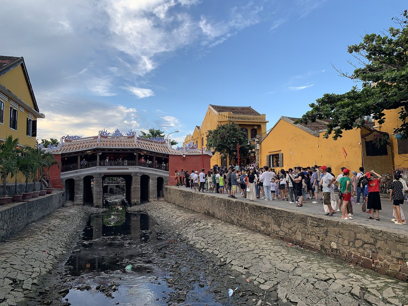
The bridge stood at the head of one of the largest Chinese streets in the port. The creek is now close to ten metres across, and the two ends of the bridge open onto Trần Phú street and Nguyễn Thị Minh Khai street. The crossing sits where the two rows of shophouses had to meet.
Merchants of the monsoon
By the end of the sixteenth century the port was known to Europeans as Faifo and was among the busiest on the East Sea. Japanese traders built on the western bank of the creek, the Chinese quarter stood opposite, and the two sides put a roofed bridge between them. The tiles ran unbroken from one end to the other, which kept silk dry through a rainy season.
The monument dossier compiled by Trần Ánh in 1992 is specific about who paid and who cut the timber. Japanese merchants put up the capital and the design, and Vietnamese carpenters working in Hội An did the building. The bridge carries the name of one country, the money of that country, and the hands of another.
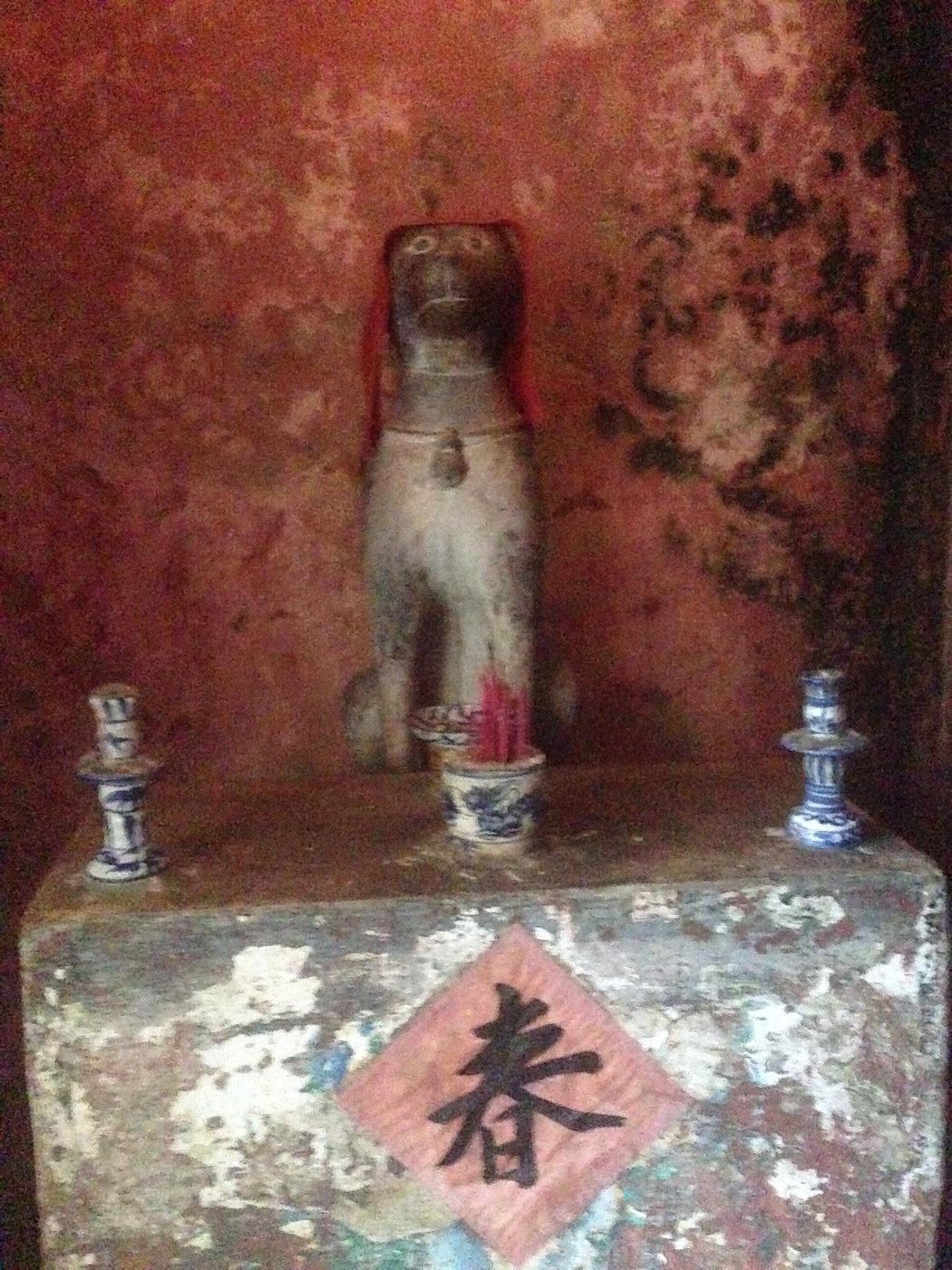
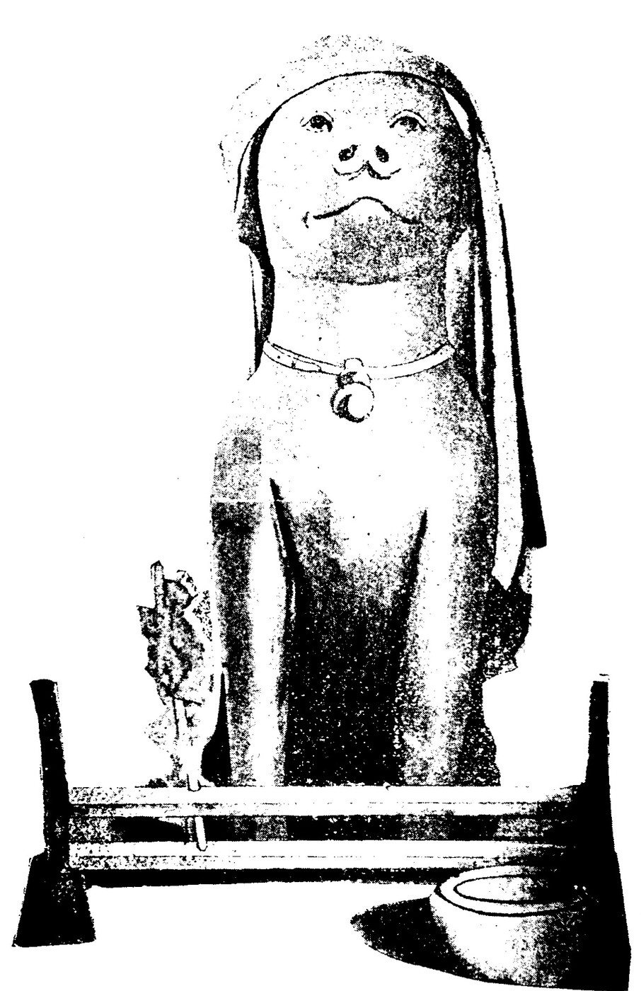
A pair of monkeys sits at one end of the bridge and a pair of dogs at the other, on altars, sometimes wrapped in red cloth with incense burning. The explanation people give is that work began in a year of the monkey and finished in a year of the dog. The earliest written record of that explanation is in Quảng Nam xã chí, a provincial register whose compilers wrote the Minh Hương section in 1943 and 1944, and it names the years: Giáp Thân 1644 to Bính Tuất 1646. Sallet recorded the same explanation in 1919 and said plainly that he could establish nothing about the origin or the meaning of the figures. The explanation reached paper about three centuries after the thing it explains.
The date 1593 is what the town hands down, and no text supports it. Between 1633 and 1635 the shogunate ordered Japanese abroad to come home and then closed the sea crossings altogether, and the Japanese quarter at Hội An thinned and ended. The bridge stayed after the men who built it could no longer return.
The pagoda with no Buddha
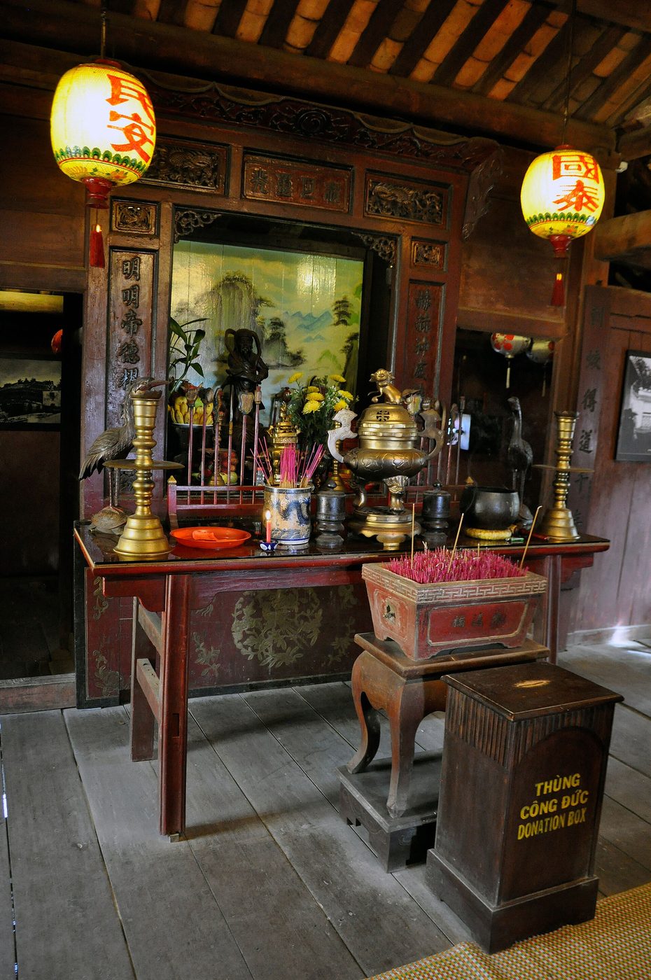
The people of Minh Hương village added a small shrine to the northern flank of the bridge and installed Bắc Đế Trấn Vũ, the northern deity who governs wind, rain and water. That shrine gave the bridge the name the town uses, Chùa Cầu, the pagoda on the bridge. It has never held a Buddha.
The year 1653 rests on a single document. Trương Đình Hoanh wrote it into a village record called Minh Hương tam bảo vụ in 1972, three centuries after the event. The special issue on the bridge that the Hội An heritage centre published in 2021 states the gap without softening it: nobody has found a source describing the event.
The story the town tells is stranger than the shrine. A water monster lies under the ground, called con Cù in Vietnamese, Namazu in Japanese and Câu Long in Chinese. The accounts disagree about which end of it lies where, some placing the head in India and the tail in Japan and others the reverse. Its back runs beneath Hội An. When it shifts, the streets slide into the water, and when its tail moves, Japan shakes. A Japanese geomancer found the spot, had a gold sword cast and driven into the spine, and raised a bridge above it. The creature would not lie still, and storm water carried off every foundation the builders laid, so they melted lead and silver into the creek bed and set the stone piers on that.
Con Cù was in the language before the bridge existed. The Đại Nam Quấc âm tự vị, a Vietnamese dictionary printed at Sài Gòn in 1895, defines cù as a hornless dragon that lies underground, and adds that where it rises a river forms. Across the sea the Japanese had Namazu, a giant catfish in the mud whose tail brings earthquakes and whom the deity Kashima pins under a stone. Before 1970 Japan had 130 Namazu shrines, most of them placed on dangerous ground near rivers and marshes.
Two coasts each had a monster. At this creek the two became one, and people built a bridge on its back.
The blind fortune-tellers on the bridge
Bénigne Vachet, a French priest born at Dijon in 1641, reached Đàng Trong, the southern realm European charts called CochinchinaHISTORICAL EXONYMCochinchinaAn old place name that meant different parts of Việt Nam in different periods. In the 16th and 17th centuries Europeans used it for the whole of Đại Việt, or for Đàng Trong alone — the southern realm of the Nguyễn lords. Under French rule the sense narrowed again, to Nam Kỳ, the south of the country. The land it named was Vietnamese throughout; only the foreigners' word for it kept moving., in 1673 and stayed until about 1683. He spent most of that time at Faifo, where the Paris Foreign Missions kept a house. In his memoir he wrote that blind men in Đàng Trong made their living on roofed bridges, telling fortunes for anyone who gave them two liards.
Then he told a story. Vachet sent a young Catholic soldier whose voice sounded like a woman's to test the blind fortune-teller on the bridge. The man announced that the lady was carrying a son. The soldier hit him hard enough to nearly knock him into the water. The case went up to the ruling lord, the court laughed, and the lord gave the soldier money and sent him home. Vachet closed by saying that for the rest of his years in the country he never saw another blind man on their bridge.
Léopold Cadière printed the passage in 1920 and argued that Faifo had never had more than one roofed bridge, so the scene had to be this one. He dated the episode to some point after 1675.
The earliest written evidence for Chùa Cầu gives no date of building. It records something firmer: that men were already sitting on it to tell fortunes.
A bridge for friends from afar
In 1686 Đỗ Bá drew the bridge into Thiên Nam tứ chí lộ đồ thư, a route atlas, and wrote three characters beside it, 會安橋, the Hội An bridge. Phạm Đình Hổ drew it again in an atlas of the late eighteenth century. The bridge entered the maps before it entered the chronicles.
In 1695 the Chinese monk Thích Đại Sán came to Đàng Trong at the invitation of Lord Nguyễn Phúc Chu and spent time at Hội An. His travel record describes a street three or four dặm long running along the river bank, with shophouses packed against one another. The shopkeepers were all Fujianese and still dressed in the manner of the fallen Ming, and women handled most of the trade. Then he fixes the bridge: at the end of the street stands the Japanese bridge.
In 1719 Lord Nguyễn Phúc Chu travelled south. Đại Nam thực lục, the dynastic chronicle, records that his carriage reached the port in the third lunar month of the year Kỷ Hợi, the twenty-eighth of his reign. He saw a bridge west of the street where the trading junks gathered, gave it the name Lai Viễn bridgeAS THE CHRONICLE HAS ITnên đặt là cầu Lai ViễnĐại Nam thực lục tiền biên, quyển 8 (bản dịch Nxb Giáo dục 2007, tr. 137), and wrote the name out for a gilt board. Lai Viễn echoes the opening of the Analects, where a friend arriving from a distant place is a cause for gladness.
A bridge for friends who come from afar.
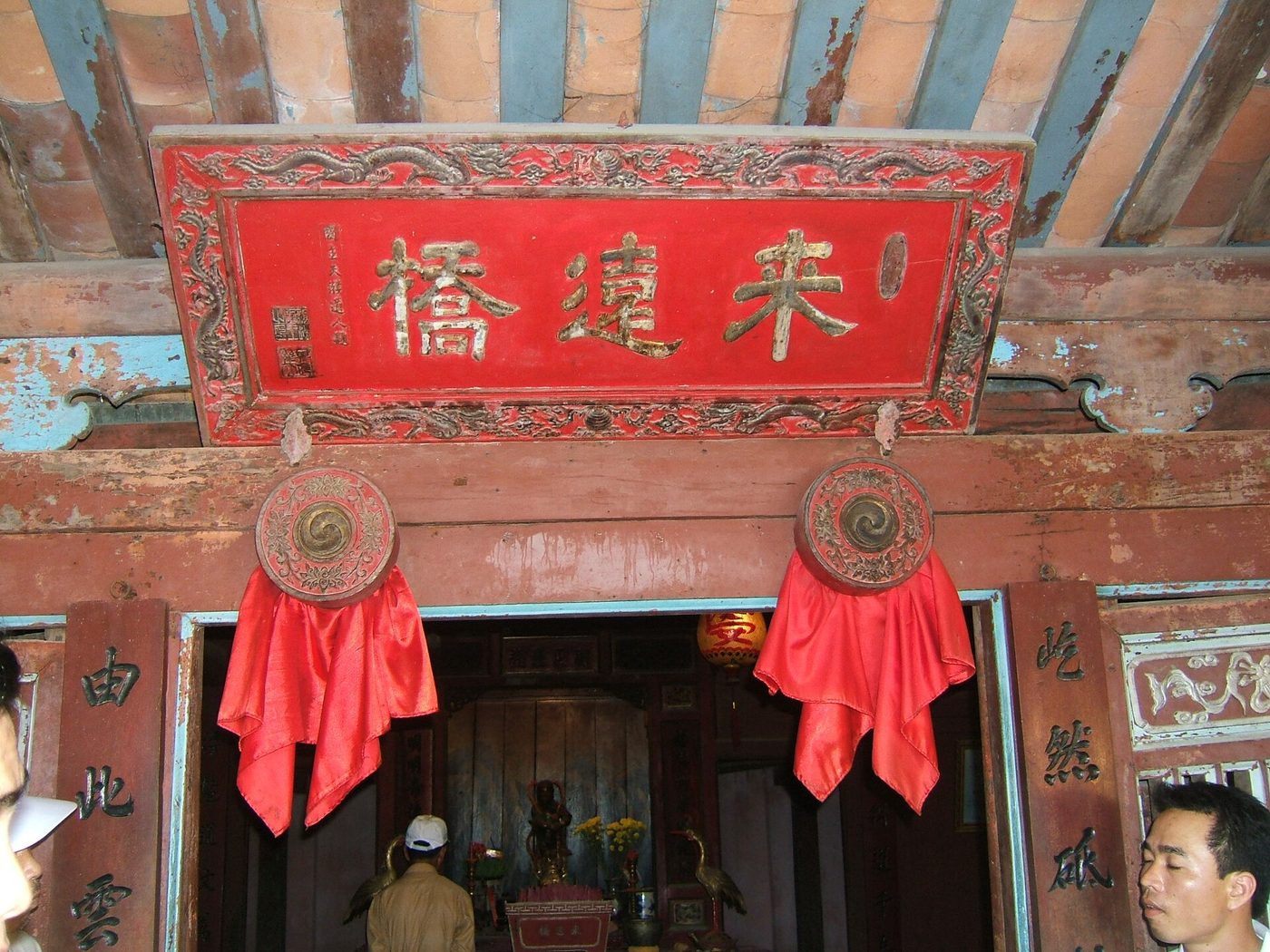
Sallet could still read the dedication on the board in 1919: the ruling lord, religious name Thiên Túng. Thiên Túng đạo nhân was the taoist name of Nguyễn Phúc Chu, and the lord's seal is still in the left corner of the panel. Covered bridges are common in Vietnam. A covered bridge raised by foreign merchants and then given a literary name by the lord of the realm is not.
The headman and a year of collecting
Along the ridge of the bridge run beams the Vietnamese call xà cò, and at each restoration the carpenters cut a line into one of them. The earliest still legible is dated the year Quý Mùi, 1763. It names Trương Hoằng Cơ, headman of Minh Hương village, rebuilding the bridge with the whole village behind him.
A village order from the following year, catalogued A18-MH and held at the Hội An heritage centre, carries the account on. It records that the bridge had decayed with the years, that the headman Trương Hoằng Cơ called on willing people in the port to contribute, and that the work took more than a year to finish. The order does not say what it cost. It says only that the collecting and the building together ran past twelve months.
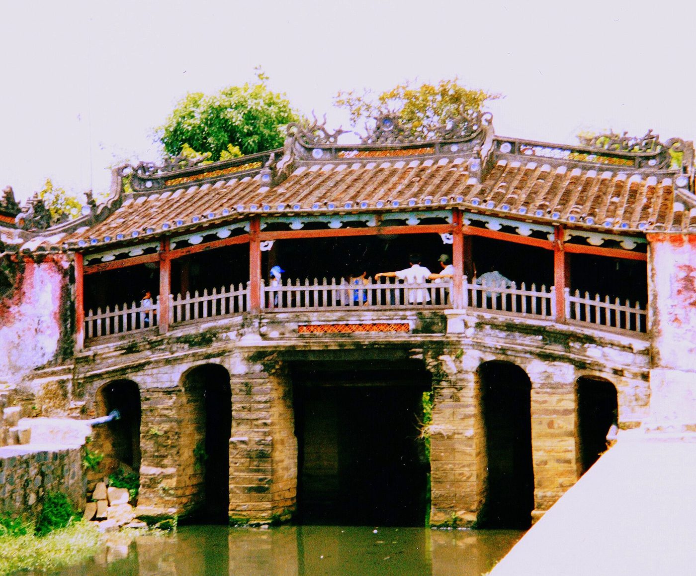
In 1806 the geographical compendium Hoàng Việt nhất thống dư địa chí, compiled under Lê Quang Định, described the bridge more closely than anything before it. It was eight tầm long and two tầm wide, and people knew it locally as the tiled bridge. Stone piers stood below and plank and timber above, with nine bays under tile. A board carried the three gilt characters Lai Viễn kiều, and a gilt panel carried the seven characters of the lord's dedication. It adds one detail that later descriptions drop. Goods of every kind were on sale down both sides of the bridge.
Under Emperor Tự Đức the imperial gazetteer counted seven bays rather than nine. Two official compilations, two numbers. The survey of the standing structure settles it: the main roof covers five bays and two half-bays, and the two bays at the ends, which rest on solid ground, bring the count to nine. The bridge did not shrink. Two compilers counted it two ways.
A stone that says the timber will rot
In 1817, the sixteenth year of Emperor Gia Long, the officials, elders and people of Minh Hương village carried out a major rebuilding. The carpenters cut the date and the hour into a ridge beam. At the end of the bridge the village raised a stone bearing an essay titled Trùng tu Lai Viễn kiều ký, an account of the restoration of Lai Viễn bridge. The stone is still there. Its author was the provincial director of studies for Quảng Nam, a man surnamed Đinh whose given name the sources write two ways, Đinh Phiên and Đinh Tường. This archive has not settled which.
The essay opens with the sentence everyone since has quoted. At Minh Hương in the port of Hội An, on the boundary with Cẩm Phô, there is a creek, and over the creek a bridge. The bridge is old, handed down as the work of men of the country of JapanAS THE STONE HAS ITNhật Bản quốc nhân sở tácBia “Trùng tu Lai Viễn kiều ký”, 1817 — dẫn theo Di sản Hán Nôm Hội An, tập 1. It then describes a bridge in use: roofed above and planked below, so level underfoot that crossing feels like walking on flat ground. A tired traveller sits down there to breathe. Visitors take the cool air, lean on the rail, watch the water run below and compose verses.
The reason for the stone comes further down. Things that rise also decay, the essay says, and termites eat timber left long enough, and a bridge nobody repairs in time will end in trouble. So the officers of the village volunteered what money and labour they had. The inscription closes with a verse of five lines whose last reads: from now on, much convenience.
The village put up a stone in a trading street to record that the wood would rot, and that they already knew it.
Headmen, a commissioner, and the donors' names
In 1875, the twenty-eighth year of Tự Đức, the ridge beam carried a longer list than before: the officials and headmen of Minh Hương village together with the merchants of the port. From that repair on, traders' names stood in the same line as the village officers.
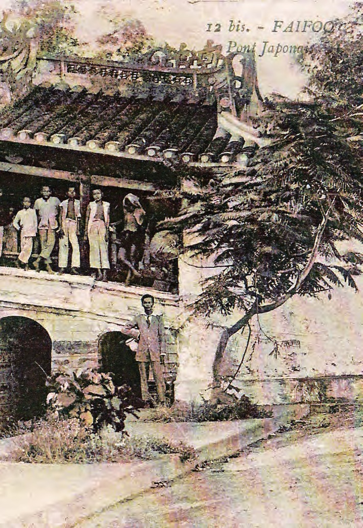
In 1915 the French senior commissioner Lesterlin Galtier approved public money for the work, and the masons cut that fact into a stone at the southern side of the western end. Sallet came through four years later and recorded a loss. That 1915 overhaul had replaced the ornament on both faces of the bridge with carved fruit, in place of simpler designs he thought better. A typhoon had carried off the little shrine some years earlier, and the village put it back up only in the first months of 1917.
In the sixth lunar month of 1917, the second year of Emperor Khải Định, the beam recorded the officers of Minh Hương village, the five heads of the Chinese congregations, and the merchants of the town. Three stones went up with the names of those who gave money. In the summer of 1918 four more appeared at the two ends, recording the terms of the work and, in clumsily cut Latin letters, the names of the French officials in charge. Sallet said outright that the placing of those stones was not a happy one.
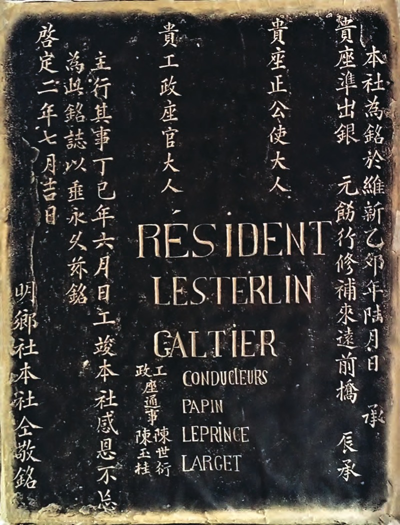
Each repair lengthened the list of people who paid for it. Four lines of beam carry a century of change in who looked after this stretch of street.
The bridge enters the register
In the fourth lunar month of 1925, the tenth year of Khải Định, the French Résidence supérieure ruled that the ancient monuments of the central region should be graded by history and by art, then recorded and preserved. The privy council put the measure up and the throne approved it. Chùa Cầu went onto the list, together with the Bảo Anh pagoda at Hội An, which the compilers of the 2021 special issue suspect is the Bảo Sanh, the Bà Mụ pagoda.
The two lists of what the French picked out do not agree, and both come from the Hội An heritage centre. Its 2021 special issue names the three best-known monuments in the town before 1930 as the Japanese bridge, the Bà Mụ pagoda and the Triều Châu assembly hall. Nguyễn Chí Trung, the centre's director, says that in 1930 the École française d'Extrême-Orient picked the bridge, the Ông Bổn pagoda and the Bà Mụ pagoda. Two names appear on both lists.
In 1962 the provincial administration of Quảng Nam repaired the bridge, replacing and strengthening the members that had rotted. The Ministry of National Education hung a board on it: classified monument, Lai Viễn kiều. Anyone who damaged it, pasted paper on it, drew or wrote on it would answer under the law then in force on the preservation of antiquities. In the same decade the province printed the bridge on its legal-document duty stamps.
For three centuries what kept the bridge standing was Minh Hương village and the merchants of the street. From 1925 it also had a statute behind it.
The year the river rose
The men who built the bridge put it where the flood keeps an appointment. Cristophoro Borri, an Italian Jesuit in Đàng Trong early in the seventeenth century, wrote that the rain fell without a break through the ninth, tenth and eleventh months. The flood covered the whole country and ran to the sea as though land and sea were one. One came every fifteen days, and each lasted three. Chùa Cầu crosses that same water.
Rain fell on Quảng Nam from 4 to 10 November 1964. On the ninth the great flood pushed the Thu Bồn over its banks. The figures published at the time counted 2,500 dead in Quảng Nam province alone and 22,447 houses taken by the water, and the village of Đông An was almost erased in a single night. The gauge at Hội An stopped at 3.40 metres.
That mark stood for sixty-one years. At half past three on the morning of 30 October 2025 the river reached it again. The bridge had reopened the previous August, after the largest restoration in its history. A photograph taken that morning shows the water up against its eaves.
From the village order to the public accounts
From August to October 1986 the Ministry of Culture and the Hội An town committee restored the roof and rebuilt the deck in the form it has today. The work cost 555,454 đồng. Over those two months 79 visiting groups came to watch the carpenters, 39 of them from abroad, and the Polish ambassador to Vietnam came with staff from the embassy.
On 17 February 1990 Chùa Cầu became one of the first three individual monuments at Hội An to be listed at national level, with the Phước Kiến assembly hall and the Tấn Ký house. On 7 July 1992 the province drew a protection boundary around it.
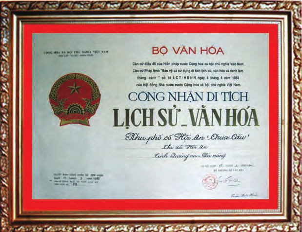
In October 1996 the town rebuilt half of the western pier on the upstream side and cast a beam into the northern wall of the shrine, at a cost of 18,236,032 đồng. On 24 July 1999 the town convened a meeting on restoring the bridge. Round the table sat the historian Phan Huy Lê, the architect Hoàng Đạo Kính, the JICA specialist Kikuchi Seiichi and Mark Chang of Showa Women's University.
A village order used to carry the cost of keeping the bridge up. Public accounts carried it now.
Taken apart to be kept
On 28 December 2022 scaffolding and a steel shed closed over the bridge. This was the eighth major restoration on record, budgeted at more than 20.2 billion đồng and split evenly between Quảng Nam province and the city of Hội An. The workers took it apart and rebuilt from the ground up: foundations, abutments and piers, then deck, timber frame, roof, wiring and termite treatment. Nineteen months later, on 3 August 2024, the city opened it again.
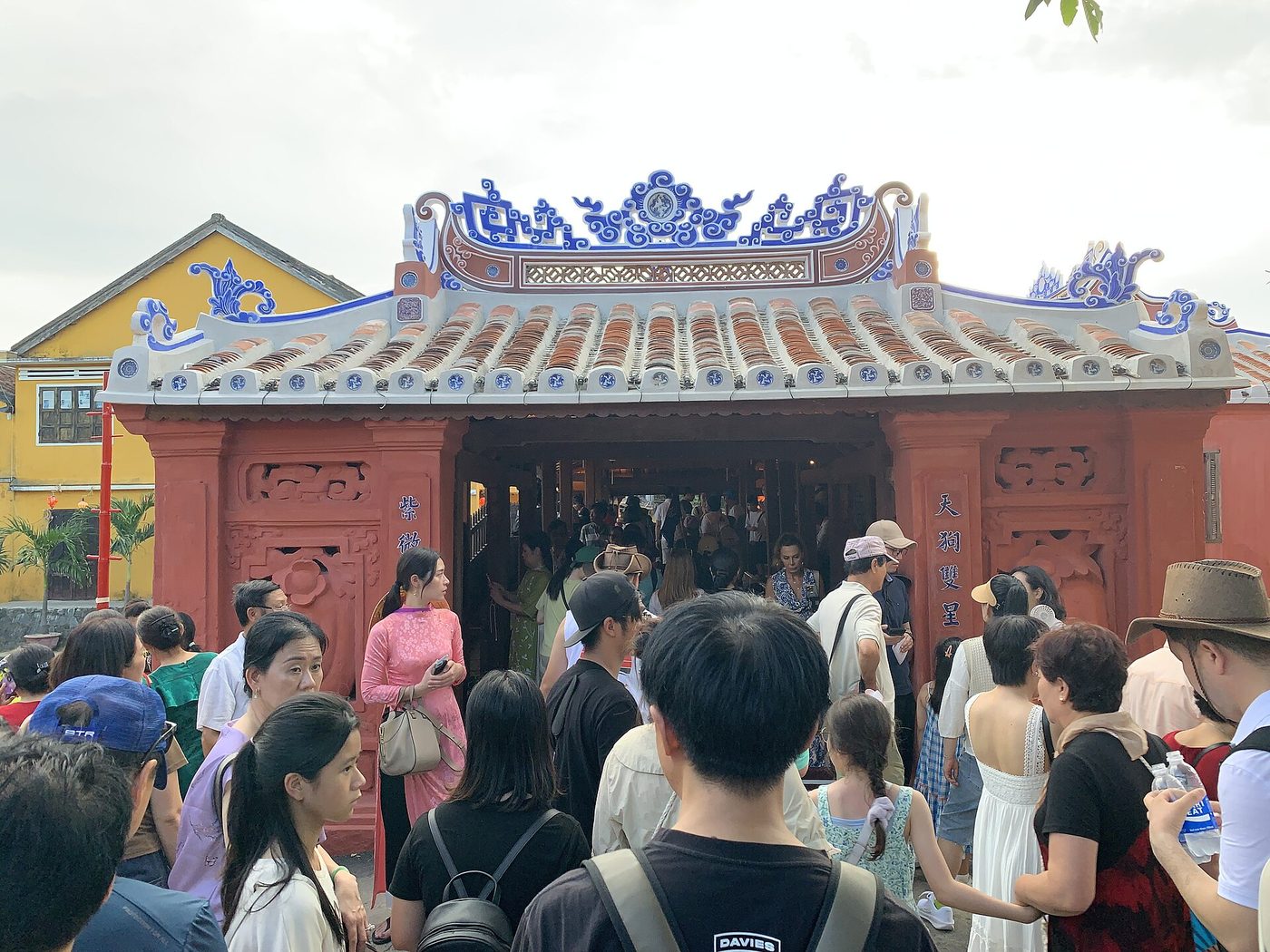
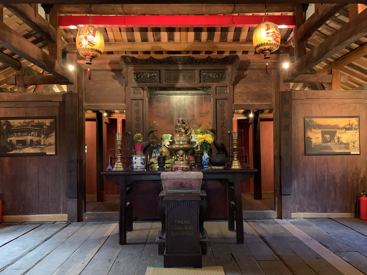
The bridge reopened and the town argued about paint. Nguyễn Đức Minh, a former deputy director of the Hội An heritage centre, praised the care taken with the carving and the interior, then said what he regretted. The painters had worked the outside unevenly and had not handled the age of the building, and tile and wall were both too strong in tone. The colour of monuments in Hội An is a lighter red, closer to the colour of a lotus petalAS HE SAID ITcó phần giống màu của cánh sen hơnNguyễn Đức Minh, nguyên Phó Giám đốc Trung tâm QLBT Di sản Văn hóa Hội An, 07/2024.
The heritage centre answered that it had taken the colours from the places on the bridge where original colour survived, together with a survey of comparable religious buildings in the town, and on the recommendation of the specialists it consulted. Nguyễn Văn Sơn, chairman of the city, said domestic specialists and staff sent from the Japanese Agency for Cultural Affairs had supervised the work. He put the principle in a line. No major restoration leaves a building unchanged, and what matters is that the original elements survive. The city still instructed the centre to repaint the front and the back in a lighter tone.
Nguyễn Sự, a former party secretary of Hội An, pointed out that new tile looks new and that a few rainy seasons would age it back. He added a sentence worth keeping whole: people and visitors praise and criticise a monument like this only because they love it.
The seven earlier repairs changed the bridge too. The one in 1915 replaced the ornament on both faces. The difference is that this time the whole country saw it in a single morning.
The bridge in everyone's wallet
In 2005 the bridge became the emblem of Hội An Ancient Town. On 17 May 2006 the State Bank of Vietnam issued a 20,000 đồng polymer note in deep blue, 136 by 65 millimetres, with a view of Chùa Cầu on the back. It is the piece of Hội An architecture that most Vietnamese carry in a wallet.


_01.jpg)
.jpg)


_after_renovation_-_portal_-_img_01.jpg)
_after_renovation_-_interior_-_img_03.jpg)

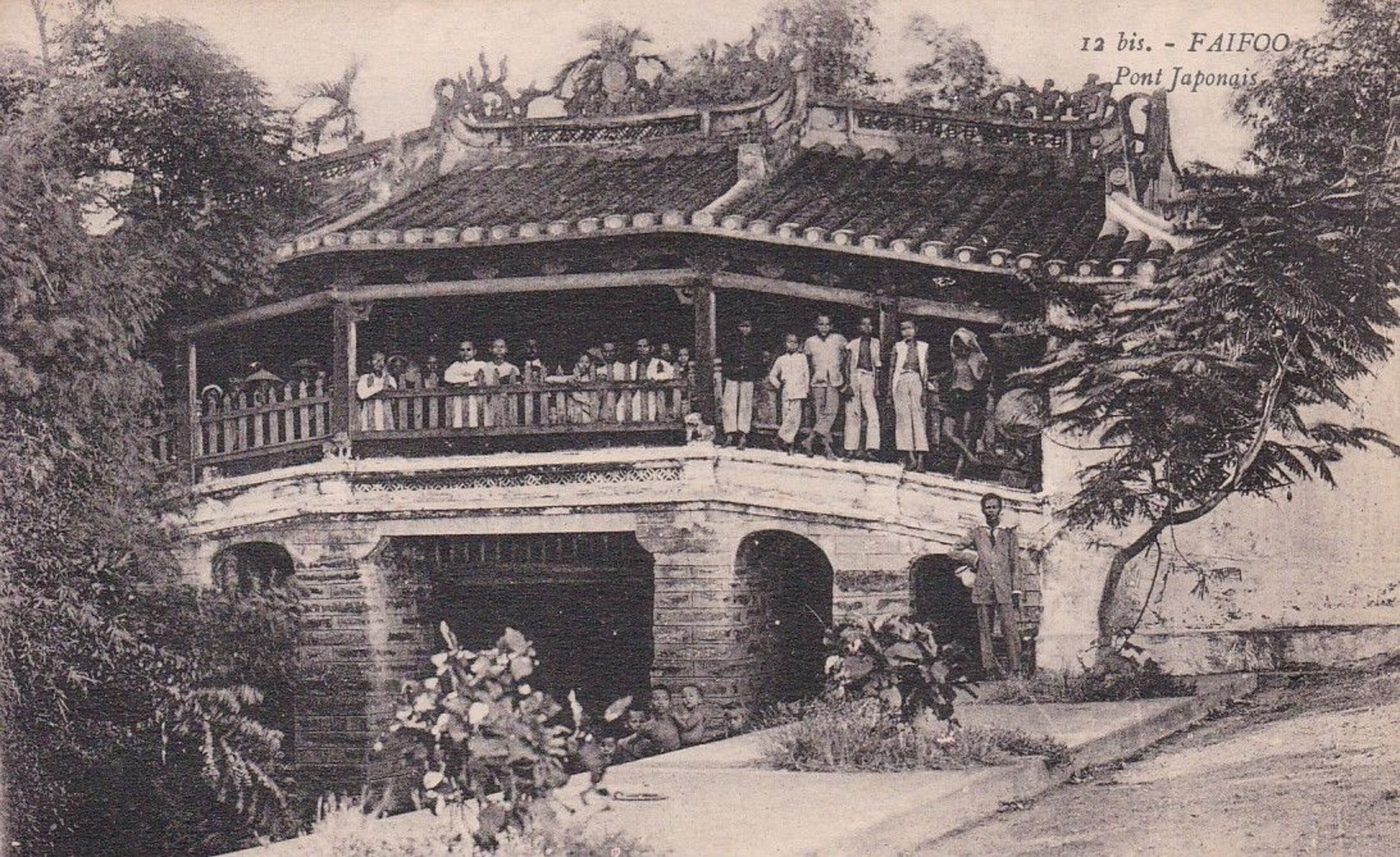 EARLY 1900s
 2024
2024Twelve roofed bridges of the thượng gia hạ kiều type survive in Vietnam, five in Nam Định, four in Hà Nội, and one each in Ninh Bình, Huế and Quảng Nam. Only three of the twelve hold worship, and only one has a separate structure built for it, joined to the bridge and still shut off from it by a timber partition. The stacked square brackets that carry the roof posts here appear in no other monument in the old town.
The survey of the standing structure is precise about how much of a four-hundred-year-old bridge is old. The foundation is close to intact. The repairs took out the lime, the brick and most of the timber. The four centuries are not in the grain of the wood. They are in the position, in the shape, and in the fact that every generation found the money to mend it.
Japanese merchants paid for it and Vietnamese carpenters built it. Minh Hương village kept it for two and a half centuries, a Nguyễn lord gave it three characters, the French put it on a register, and the state prints it on a banknote. The part of the bridge that is most nearly original is the part nobody sees.
- Trung tâm Quản lý Bảo tồn Di sản Văn hóa Hội An, “Thông tin nghiên cứu Bảo tồn Di sản” Tập 03(55)-2021, chuyên đề Di tích Chùa Cầu, Nxb Đà Nẵng, 182 tr., 24 bài — nguồn xương sống của mục này
- Võ Hồng Việt, “Những sự kiện về di tích Chùa Cầu”, đặc san đã dẫn, tr. 46–51 — biên niên có chú nguồn từng mốc, từ xà cò 1763 tới doodle Google 2019
- Trần Thanh Hoàng Phúc, “Hiện trạng và giá trị về kiến trúc nghệ thuật của di tích Chùa Cầu”, đặc san đã dẫn, tr. 68–77 — số đo hiện trạng, bộ vì kèo, so sánh với 11 cầu ngói còn lại ở Việt Nam
- “Tổng quan các nguồn tài liệu và nghiên cứu về di tích Chùa Cầu”, đặc san đã dẫn, tr. 138–145 — kiểm kê mọi thư tịch, thác bản và tư liệu lưu trữ từng chép về cây cầu
- “Từ tín ngưỡng dân gian đến tục thờ Bắc Đế Trấn Vũ ở Chùa Cầu”, đặc san đã dẫn, tr. 103–108 — Namazu, Bắc Đế, và chế độ lụt của hạ lưu Thu Bồn
- “Bề dày lịch sử văn hóa của Chùa Cầu nhìn từ một truyền thuyết”, đặc san đã dẫn, tr. 42–45 — bản đầy đủ của truyền thuyết Trấn Cù dậy
- Quốc sử quán triều Nguyễn, “Đại Nam thực lục tiền biên” quyển 8 (bản dịch Nxb Giáo dục 2007, tr. 137) — chép việc chúa Nguyễn Phúc Chu đặt tên cầu Lai Viễn năm Kỷ Hợi 1719. Dẫn theo đặc san đã dẫn và bản mộc bản
- Quốc sử quán triều Nguyễn, “Đại Nam nhất thống chí” (bản dịch Nxb Thuận Hóa 1997, t.2 tr. 379) — cầu Lai Viễn “gác mái gồm bảy gian lợp ngói”. Dẫn theo đặc san đã dẫn
- Lê Quang Định, “Hoàng Việt nhất thống dư địa chí” hoàn thành Gia Long thứ 5 (1806), bản Phan Đăng dịch, tr. 290 — cầu dài 8 tầm rộng 2 tầm, chín gian lợp ngói, hai bên bày bán hàng hóa. Dẫn theo đặc san đã dẫn
- “Quảng Nam xã chí” ký hiệu AJ23.7, Viện Nghiên cứu Hán Nôm, phần làng Minh Hương ghi 1943–1944 — bản ghi sớm nhất của lối giải thích khỉ và chó, và của việc chôn kiếm vàng. Dẫn theo đặc san đã dẫn
- Trát văn xã Minh Hương ký hiệu A18-MH (1764), lưu tại Trung tâm QLBT Di sản Văn hóa Hội An — việc duyên thủ Trương Hoằng Cơ kêu gọi quyên góp, trùng tu hơn một năm mới xong. Dẫn theo đặc san đã dẫn
- “Minh Hương tam bảo vụ”, Trương Đình Hoanh, 1972, lưu tại Trung tâm QLBT Di sản Văn hóa Hội An — nguồn duy nhất của mốc 1653. Dẫn theo đặc san đã dẫn
- Nhóm nghiên cứu Hội An, “Di sản Hán Nôm Hội An” tập 1 – Văn bia (2014), tr. 185–192 — bia “Trùng tu Lai Viễn kiều ký” năm Đinh Sửu, Gia Long thứ 16. Dẫn theo đặc san đã dẫn
- Huỳnh Tịnh Paulus Của, “Đại Nam Quấc âm tự vị”, Sài Gòn 1895, tr. 194 — mục từ “Cù” và “Cù dậy”. Dẫn theo đặc san đã dẫn
- Hosoda Hiroko, “Namazu — Truyền thuyết và tín ngưỡng”, Nxb Ribun 1970, tr. 156–167 — 130 đền thờ Namazu ở Nhật trước 1970. Dẫn theo đặc san đã dẫn
- Cristophoro Borri, “Xứ Đàng Trong năm 1621” (bản dịch Nxb TP.HCM 1998, tr. 15) — chế độ lụt Đàng Trong thế kỷ XVII. Dẫn theo đặc san đã dẫn
- Cristoforo Borri, “Relation de la nouvelle mission des peres de la Compagnie de Iesus au royaume de la Cochinchine”, Rennes 1631 — nguyên bản tiếng Pháp
- A. Sallet, “Le Vieux Faifo — II. Souvenirs japonais”, Bulletin des Amis du Vieux Huế 1919 số 4, tr. 508–515 — số đo năm 1919, bốn dòng xà cò, biển Lai Viễn kiều, lễ Bắc Đế, đợt đại tu 1915 và bốn tấm bia hè 1918
- L. Cadière, “Sur le pont de Faifo, au XVIIe siècle: historiette tragi-comique”, BAVH 1920 số 3, tr. 349–358 — hồi ký Bénigne Vachet, chứng cứ thành văn sớm nhất về cây cầu
- Thích Đại Sán, “Hải ngoại kỷ sự” (1695), quyển 1 — bản chữ Hán 識典古籍
- “Chùa Cầu — dấu ấn người Nhật trên phố cổ Hội An” — Trung tâm Lưu trữ quốc gia IV, mocban.vn (nguyên văn mộc bản Đại Nam thực lục tiền biên q.8 và Đại Nam nhất thống chí q.5)
- “Chùa Cầu Hội An — Những lần tu bổ” — Trung tâm QLBT Di sản Văn hóa Hội An, 19/08/2016
- “Chùa Cầu Hội An — một di tích độc đáo về kiến trúc nghệ thuật” — Trung tâm QLBT Di sản Văn hóa Hội An
- “Bia trùng tu Lai Viễn Kiều ký” — Báo Quảng Nam, 2018
- “Năm 1930, Viện Viễn Đông Bác Cổ đã chấm chọn chùa Cầu, chùa Ông Bổn và chùa Bà Mụ là cổ tích liệt hạng của Việt Nam” — Trung tâm QLBT Di sản Văn hóa Hội An
- “Đại trùng tu chùa Cầu, Hội An: Nhiều ý kiến trái chiều” — Sài Gòn Giải Phóng, 30/07/2024 (kinh phí, tiến độ, ý kiến Nguyễn Đức Minh, Nguyễn Sự và Nguyễn Văn Sơn)
- “Diện mạo Chùa Cầu sau khi trùng tu” — Trung tâm QLBT Di sản Văn hóa Hội An, 26/07/2024
- “Hoi An's Cau Pagoda reopened after restoration” — VietnamPlus (hạng mục thi công và lễ khánh thành 3/8/2024)
- “Đại hồng thủy 1964, ác mộng làng Đông An” — Tuổi Trẻ, 26/10/2025
- “Nước sông Thu Bồn vượt đỉnh lũ ‘đại hồng thủy’ năm 1964” — Dân trí, 30/10/2025
- “Hình ảnh nước lụt ở Hội An sáng nay chạm mốc lịch sử năm Thìn 1964” — Tuổi Trẻ, 30/10/2025
- “Tiền polymer mệnh giá 20.000 đồng bắt đầu đi vào lưu thông” — Báo Chính phủ
- “Những hình ảnh lịch sử của Chùa Cầu Hội An” — Tuổi Trẻ, 31/07/2024
- Faifoo – Pont Japonais — Unknown photographer, Public domain
- Statuo de hundo sur la Japana ponto (Hoi An) 01 — RG72, CC BY-SA 4.0
- Le Vieux Faifo — II. Souvenirs japonais, Bulletin des Amis du Vieux Huế 1919 no 4 — Albert Sallet, Public domain
- Hoi An – Altar inside Chùa Cầu — P. Hughes, CC BY 4.0
- Chua Cau inside — Khương Việt Hà, Public domain
- Lai Vien kieu — Viethavvh, Public domain
- Chùa Cầu – 2003 — Benoît Prieur, CC0
- Thông tin nghiên cứu Bảo tồn Di sản, Tập 03(55)-2021 — chuyên đề Di tích Chùa Cầu — Trung tâm Quản lý Bảo tồn Di sản Văn hóa Hội An, Bản quyền tác giả
- 2024 Hội An – Chùa Cầu after renovation, portal — Chainwit., CC BY 4.0
- 2024 Hội An – Chùa Cầu after renovation, interior — Chainwit., CC BY 4.0
- Emblem of Hoian City — Hai Trieu Nguyen, Public domain
- 2024 Hội An – Chùa Cầu after renovation — Chainwit., CC BY 4.0
_after_renovation_-_img_03.jpg)